Hull is on it's way to be a Smart City
Just before Christmas, I went along to the first HullStack, a rebirth of CodePen (which I’ve written about on this blog previously), but now with a new name that’s wider than code, and covers the full industry from concept through to implementation.
This time, it was Adam from Hull City Council who was talking about Hull’s journey to become a smart city. It’s a bit of a late blog post write up, but it was a really interesting talk. It’s cool to see how a city approaches implementing a system on such a large scale.

Smart Cities are often a buzzword that gets thrown around, much like blockchain, and they’re an area of vast growth. London, Manchester and Liverpool are exploring the path to being smart cities; however, in most areas, development is being led by developers and companies without a lot of buy-in from the local authorities.
Hull is attempting a very different approach and has created a vision to open up their 300 internal services by 2023, and leading smart development from inside the council, and taking the view that if something can be FOI’d, it should be available openly in the first place.
They’re attempting to open up all of Hull, and give developers and entrepreneurs the ability to solve, and create products from technical challenges around their own city.
A big problem that Hull has are bridges, there are 13 of them across the City, and it’s a pretty unique situation to have so many of them close together. At the moment there’s a >24-hour notice period between informing the bridge when they need to open and when they open, the email currently just sits in the bridge operators inbox. These should be available in an API, so it can be consumed by mapping operators to smartly redirect traffic, or inform drivers if bridges are closed, or will be closed when they arrive there and so that blue-light services don’t get stuck at bridges too.
Buses are another big one, and I was reading about it a couple of days ago on GOV.UK here. Bus operators are required by December 2020 to provide live timetable data, and by January 2021 to provide live vehicle location and fare data to the Department for Transport. Hull is working with local bus providers to implement these SIRI (Service Interface for Real-Time Information) feeds early to bring live stop times to Hull’s interchange and increase the accuracy of the signage at all the stops across the area.
Around Hull there are 317 scoot loops, these provide data of how many cars drive through a junction in 5 minutes, their average speed, and the direction they’re travelling from and to. You can see how TGFM have a similar API here. Opening this data showing where cars are going, and how many of them at certain times will help reduce that congestion as this data can highlight alternate quieter routes.
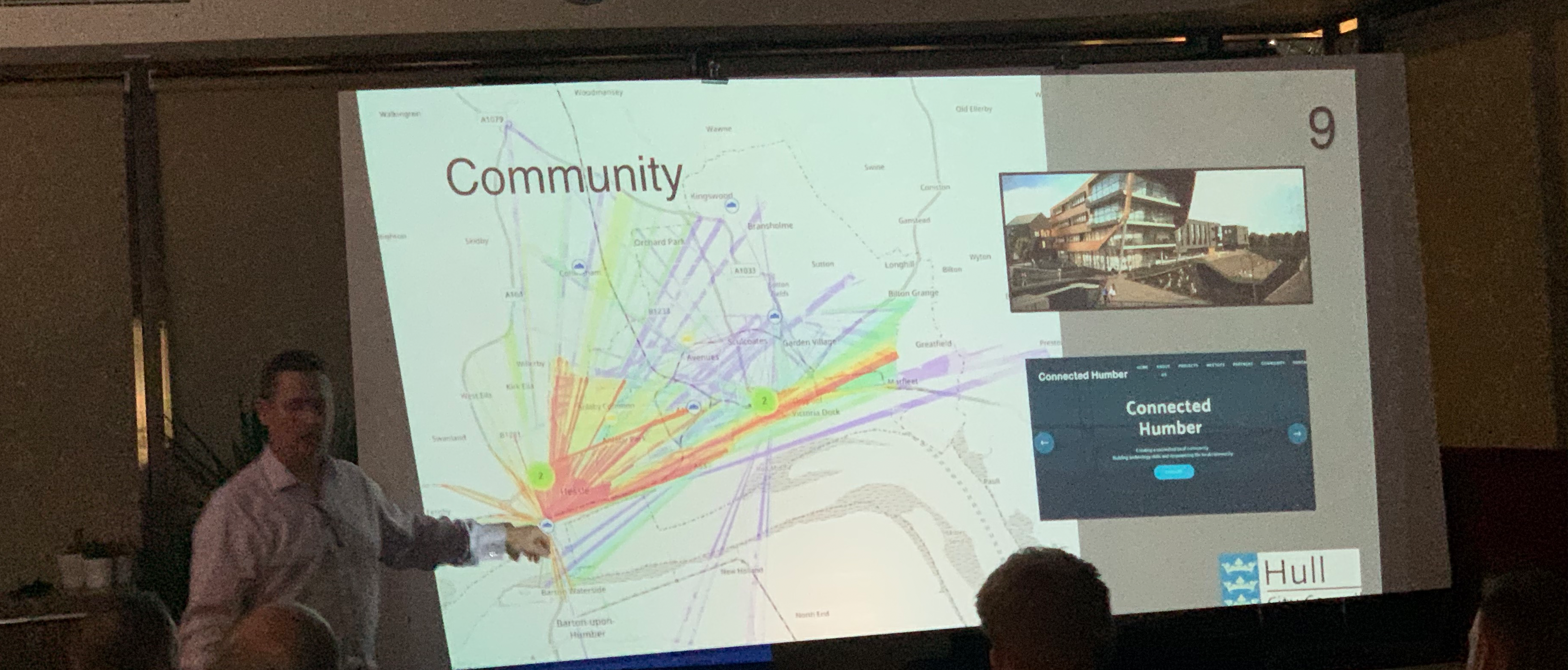
Mobile operators provide anonymised data that shows groups of mobile phones moving through the City, and it can give historical patterns for groups moving through. The data will allow the council to see where cycle paths don’t get used for instance, and to put in more infrastructure where people will use it the most. With this data open, it will mean that businesses can open in higher footfall areas, or areas can be improved to attract people back.
Next up CCTV, there are around 360 council-controlled CCTV cameras around the area, including traffic cameras, by using computer vision on these images to produce new statistics that weren’t previously available, like the most common routes for HGV travel. It could also show where buses get held for the longest in bus lane merges, and where road layouts don’t work. Parking has already opened up with live spaces data available here, but they’re looking to create an enhanced mapping of the streets for self-driving cars.
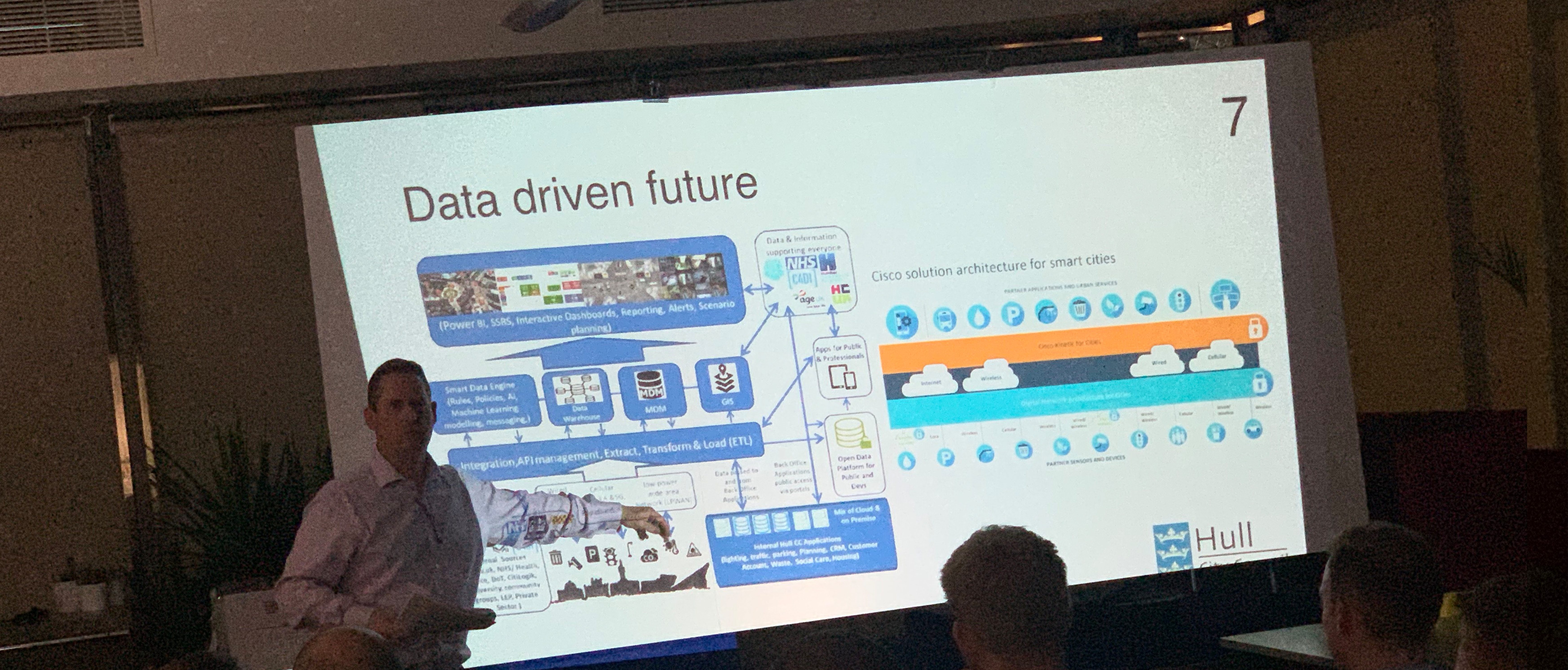
Through combining all of these in their ‘CityOS’ platform in partnership with Connexin, they’re hoping to create a vast network of open data to allow developers to connect to their entire City with APIs.
Their approach to technical development is exciting, as the Hull tax-payer is at the end of the day, the one who will pay for this development. The council want local people to work with them to develop innovative solutions, which Hull can then help the creators tender to other areas like the 342 other UK councils, but securing Hull’s place as the pioneer of fully-connected cities.
LoRaWAN is significant for Hull too, as they have the largest network in the UK with the City installing base stations, including on the Humber Bridge. The signal has a range of 16km and allows sensors to connect to the internet and into the CityOS platform. The sensors are currently used for air quality detection, and smart bins are being trialled to provide real-time data on bin use, and save the council money meaning they only need to be emptied when they fill up.
It’s an amazing time of technical revolution to be about for, and I’m intrigued to see what comes next from the City. I’m also really interested for the open-data hackathon that they’re hoping to hold later in the Spring.
Thanks to Adam Jennison for presenting, and to Mark, HullStack and C4DI for running the event!
HullStack brand all rights reserved - HullStack, City of Culture event image from Visit Hull courtesy of Hull City Council.